Last year, a flood that used to be a “once in a century” event hit Nashville twice in one spring. In Phoenix, the heat forced city leaders to fast-track new shade requirements for every new development. And in Charleston, rising seas have turned once pristine waterfront lots into uninsurable liabilities. These aren’t isolated headlines. They are the new normal. And they are why urban planners across the United States are realizing that the zoning codes written in the 20th century simply cannot handle the climate of 2026.
The old rules were built on stability. They assumed flood zones stayed put, that temperatures followed predictable ranges, and that the land you could build on today would be safe for decades. Climate change has shattered those assumptions. Sea levels are rising faster than models predicted. Wildfire seasons are longer and more intense. Heat domes are baking regions that never needed air conditioning. Zoning laws, the quiet backbone of every city’s development strategy, are being rewritten on the fly.
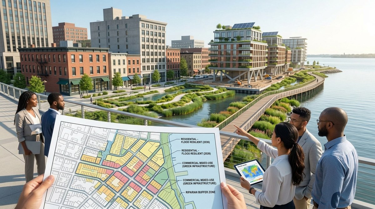
Climate change zoning laws are no longer a theoretical debate. In 2026, cities from Miami to Portland are actively rewriting codes to manage flood risk, extreme heat, and wildfire danger. This guide shows planners how to adopt climate informed zoning using real world examples, a step by step process, and common pitfalls to avoid. The goal is safer, more equitable neighborhoods that can withstand the next decade.
The Old Rules No Longer Fit
Traditional zoning separates uses. It puts houses in one area, shops in another, and industry somewhere else. It also defines how tall buildings can be, how much parking is required, and where green space must go. These rules were created for a world that was stable and predictable. That world no longer exists.
Climate change introduces dynamic risks. A floodplain map printed five years ago is already out of date. A wildfire hazard zone shifts with drought patterns. An urban heat island intensifies as concrete absorbs more solar radiation. Planners cannot simply update a map every ten years and call it done. They need zoning codes that adapt as conditions change.
Consider how a single heavy rainfall event can overwhelm a city’s drainage system. If the zoning code doesn’t require permeable surfaces or adequate stormwater retention, that flood devastates entire blocks. The same logic applies to heat. If the code doesn’t mandate tree canopy coverage or cool roofs, a heat wave can turn a neighborhood into a literal oven.
How Zoning Laws Are Adapting Right Now
Across the country, cities are experimenting with new approaches. Some are already showing promising results.
Norfolk, Virginia is a standout. The city uses a climate informed zoning overlay that requires new buildings in flood prone areas to be elevated at least three feet above the base flood elevation. Developers must also include on site stormwater management. Norfolk’s approach doesn’t just react to flooding; it proactively shapes how the city grows.
Miami Beach has gone further. It raised roadways, installed massive pumps, and now requires all new construction to build to a “resilient” standard that includes floodproofing and elevated electrical systems. The zoning code was rewritten to discourage ground floor habitation in low lying areas.
Portland, Oregon addresses extreme heat. Its new zoning code includes a “green infrastructure” requirement for any new development over a certain size. Developers must provide shade trees, green roofs, or cool pavement. The code also encourages cross ventilation in building design, reducing reliance on energy hungry air conditioning.
California’s wildfire zones have seen some of the most aggressive changes. Several counties now require “defensible space” buffers between structures and wildland vegetation. New subdivisions must include fire resistant landscaping and non combustible fencing. Building setbacks have been increased in high risk areas.
“The days of static zoning are over. We need codes that can be updated annually based on the latest climate data. Planners should treat zoning like a living document, not set in stone.” — Lia Chen, urban resilience consultant and former planning director for San Diego
A Practical Framework for Updating Zoning Codes
For planners who want to start rewriting their own climate change zoning laws, a structured process helps avoid chaos. Here is a five step framework used by cities that have already made progress.
-
Conduct a climate vulnerability audit. Map your city’s current and projected risks. Use the latest NOAA flood projections, FEMA maps, and local heat island data. Identify which neighborhoods are most exposed. This data becomes the foundation for every zoning change.
-
Identify zoning districts that need overlay zones. Overlay zones let you add special rules on top of existing zoning. They are easier to adopt than rewriting an entire code. Target floodplains, heat vulnerable areas, and wildfire corridors.
-
Engage the community early and often. Zoning changes can feel threatening to homeowners and businesses. Hold open houses, share visual simulations of future conditions, and explain why the rules are changing. People support adaptation when they understand the risks.
-
Pilot the new rules in a small area before expanding. Choose a single neighborhood or district. Test the new requirements for at least one building season. Gather feedback on cost, feasibility, and unintended consequences. Adjust before scaling up.
-
Build a review cycle into the code. Climate data updates every year. Your zoning code should have a built in trigger for review. For example, require the planning department to reassess flood overlay boundaries every three years or after any major disaster event.
Common Mistakes When Changing Zoning Laws
Even well intentioned updates can backfire. The table below outlines frequent errors and how to avoid them.
| Mistake | Consequence | Better Approach |
|---|---|---|
| Using outdated or static hazard maps | New buildings get built in areas that flood or burn within a few years | Use dynamic, regularly updated data sources and require annual map reviews |
| Ignoring equity and displacement risks | Low income residents are priced out of safer areas | Pair zoning changes with affordable housing protections and relocation assistance |
| Making rules too rigid | Developers avoid building altogether, stalling housing supply | Offer performance based standards that allow multiple compliance pathways |
| Focusing only on new construction | Existing buildings remain vulnerable | Include retrofitting incentives and phased compliance timelines for existing structures |
What Policy Makers Need to Prioritize
If you are a planner or policy maker looking to act, prioritize these areas first. They offer the biggest safety gains for the lowest political cost.
- Equity first. Low income communities and communities of color often face the highest climate risks and have the fewest resources to adapt. Zoning changes should include anti displacement measures, such as community land trusts or density bonuses for affordable units in safer zones.
- Green infrastructure mandates. Require rain gardens, bioswales, permeable pavement, and tree canopy in all new developments. These features reduce flood risk, lower heat, and improve air quality.
- Flexible density. Allow taller or denser development outside hazard zones to steer growth away from danger areas. This also helps meet housing needs without encouraging sprawl.
- Cool building standards. Update building codes to require reflective roofs, shaded facades, and natural ventilation. These are low cost, high impact measures for urban heat resilience.
- Coordination with neighboring jurisdictions. Floods, fires, and heat waves cross city lines. Work with county and regional agencies to align zoning standards so that one city’s rules don’t push risk onto its neighbor.
The Role of Technology and Data
Modern zoning depends on good data. Satellite imagery, LIDAR, and climate models now allow planners to map flood depths with street level precision. Local governments can use these tools to create zoning overlays that change as the data changes.
For example, a city might use an interactive online map where property owners can see their flood risk score before building. This transparency helps the community understand why certain areas have stricter rules. It also reduces surprises later.
Meanwhile, newer technologies like innovative technologies for climate change mitigation are making it easier to model the long term effects of different zoning scenarios. Planners can simulate a 100 year flood with today’s code and compare it to a code that requires elevated structures. The cost benefit analysis becomes clear very quickly.
A New Vision for American Neighborhoods
Climate change zoning laws are not just about avoiding disaster. They are about building neighborhoods that work better in every season. A block with wide sidewalks, shade trees, and rain gardens feels cooler, looks greener, and handles a downpour without flooding. That’s a win for everyone.
Many communities are already showing what’s possible. In Detroit, zoning changes now encourage urban agriculture and permeable lots instead of vacant concrete. In Denver, new rules require every parking lot to include shade structures or trees. In Boston, the zoning code was updated to allow “resilience hubs” — community centers with backup power and cooling stations that can serve residents during heat waves or outages.
These are not radical ideas. They are practical responses to a changing climate. And they work best when planners, residents, and local officials work together.
Making Your City’s Code Future Ready
The most important step is to start. You don’t need to rewrite every page of your zoning ordinance overnight. Choose one risk — flooding, heat, or wildfire — and update the overlay for the most vulnerable district. See how it performs. Then expand.
Talk to your city council about creating a standing climate adaptation committee that includes planners, engineers, and community representatives. Push for annual data updates. And remember that the goal is not to stop development. It is to shape development so it survives the next storm, the next heat wave, the next wildfire season.
If you would like to see how other cities are integrating renewable energy and green infrastructure into their zoning, check out this guide on innovative strategies for urban sustainability. And for a deeper look at how community led efforts are reshaping local policies, read about ways communities can lead climate adaptation.
The zoning code sitting in your planning office right now was written for a different world. You can make it fit this one. One overlay, one neighborhood, one review cycle at a time. The future of your city depends on it.